 |
|||||||||||||||||||||
|
|
|||||||||||||||||||||
|
Click on buttons, images or underlined words to find your way round this website |
|||||||||||||||||||||
|
Website visitors since 15/1/03 |
|||||||||||||||||||||
|
|
|||||||||||||||||||||
|
The route is described below from east to west, i.e. from Peterculter to Milton of Crathes.
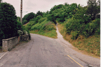
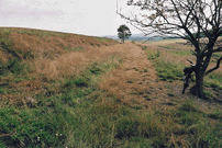
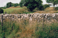
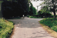
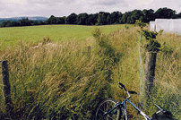
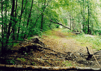
1) Culter Station to Kennerty (bridge over road): 550m. A simple pathway has already bee It is too narrow in parts for multi-purpose use and should be widened to a minimum of 2.50 metres. Resurfacing is required. Access ramps are basic and very narrow, and require improvement. There is no signage at all at present. [OS map references of the start and end-points of this section are NJ842006 and NO832001] 2) Kennerty to Coalford Croft: 1500m. The old railway track bed has not been re-surfaced, but there is a good firm base here for surfacing. Excellent views across open rural landscape (see photograph, right) and to the Normandykes Roman fort. It is recommended that route turns up short (c. 100m) farm road and joins minor road to Coalford Croft. Whilst the old railway track bed runs across the field for half a mile, there is a new dyke (see photograph, below) firmly defining the boundary of Coalford Croft and the old track bed has been The alternative is to run the path along the old track bed across the Kennerty field as far as the Coalcroft boundary, and then make a new path up to the road at this point. [OS map references of the start and end-points of this section are NO832001- NO824998] 3) Coalford Croft to Dalmaik crossroads: 1720m. The route runs along the minor road, turning left at Coalford Croft. The on-road distance is about 2.25 kilometres. This is a narrow road (about 3 metres wide). It passes through varied landscape of wood and field. Although traffic density is very low, walkers and riders should take care. There are no visibility problems. The route crosses the boundary separating Aberdeen City Council and Aberdeenshire Council at Coalford Croft. [OS map references of the start and end-points of this section are NO824998- NO809988] 4) Dalmaik crossroads to Drumoak House: 1050m The route runs between fields for the first 300 metres. Thereafter, it follows a [OS map references of the start and end-points of this section are NO809988-NO798987] The route as constructed follows the Old Deeside Road to its intersection with the Park Bridge Road. It then uses the Drumoak Glebe Path (laid by CDDCC) to the Post Office and Irvine Arms, at the centre of Drumoak. [OS map references of the start and end-points of this section are NO798987-NO793988] 6) Drumoak Irvine Arms to Park: 680m. From the Irvine Arms towards Park, path users have to make their way along the North Deeside Road for about 400 metres, using pavement and grass verge. From this point, the path continues to Park. [OS map references of the start and end-points of this section are NO793988-NO786985] The path runs alongside the N Wooden structures have replaced two bridges over farm access roads that had been been removed. [OS map references of the start and end-points of this section are NO786985-NO750964] 8) Crathes to Milton of Crathes: 880m. From east of the houses at the Crathes crossroad, the path follows the pavement along the North Deeside Road. Thereafter, the route follows the A957 (which joins the Slug Road south of Durris Bridge click here for map), then takes a right along a minor road past the old Crathes station and preserved signal box, now in private ownership. The route winds through some sandpits (where care is necessary), past the Banchory Boys Football Ground, to the medley of bridges at Milton of Crathes. From this point along to the entrance to Milton of Crathes, a new section of path has been created. [OS map references of the start and end-points of this section are NO750964-NO742963] Westwards to Banchory The railway trackbed has been used as a path from Milton of Crathes towards Banchory. The initial phase of the Royal Deeside Railway (click here for information) is now being implemented over the section of trackbed running about 1600 metres westwards from Milton of Crathes. As part of the preserved railway project, a replacement path - parallel to the railway - has been created. |
||
 n created (see photograph).
 redeveloped as a wild garden.
 farm track (shown in the picture, prior to improvement). This crosses towards Drumoak House (the old manse).
 orth Deeside Road, but at a discreet distance to make its use a much more pleasant experience than using the road itself.